


Renting Drones
![]()

![]()
![]()
![]()

Categoría de Productos Autel Evo Dragonfish
Dragonfish
N.º de producto: Dragonfish
En existencias
se puede enviar en 15 días

Dragonfish Series
Command The Future


 Dragonfish LiteDragonfish ProDragonfish Standard
Smart. Simple. Efficient.
The Dragonfish's unique tilt-rotor design simplifies operation while maximizing performance and efficiency. With no complicated moving parts, the Dragonfish is modular, waterproof, smart, and reliable. The Dragonfish is mission ready right out of the box and includes powerful AI tracking capabilities and a multitude of modular payload options. An endurance of up to 180 minutes (including payload) further augments the Dragonfish's robust mission capabilities and pushes it significantly ahead of the competition.
-
180 minutes
Longest flight time with load
-
3 minutes
Quick assembly
-
4K 50x
Highest optical zoom
-
108km/h
Max speed
-
18.6 miles
Transmission range
-
5s
System boot and self check
Endurance With Payload
The Dragonfish series includes three models: the Dragonfish Lite, Dragonfish Standard, and Dragonfish Pro. With a flight time of 75 minutes, 120 minutes, and 180 minutes respectively while carrying a payload, each model can greatly improve work efficiency.
.png "36.png")
 Dragonfish ProDragonfish StandardDragonfish Lite180 min120 min75 min
Safety and Redundancy
 Built Tough: The Aircraft's composite outer shell and carbon fiber core gives the aircraft and wind resistance rating of level 6 and IP43 weather resistance to handle complex environments with ease.Backup Modules: The Dragonfish battery, barometer, positioning system, compass, and IMU all have backup modules to ensure flight safety.Attentive AI: Vigilant AI continuously self-checks the system to prevent faults before they occur.Autel Robotics' superior flight control platform guarantees stability and reliability in every flight. High Quality Sensors:Integrated airspeed velocity sensor monitor the environment in real time, even while buffeted by snow or ice. Automatic Transition: The Dragonfish will automatically transition to multi-rotor mode if adverse conditions cause fixed winged flight to stall or become unsustainable. The Dragonfish can automatically choose which mode to fly for the best performance. Internal Communication:Dual-redundant CAN bus communication protects the aircraft from electromagnetic interference and enables the rudder surface and motor status to be monitored in real time.
DRAGONFISH FLIGHT LOGIC

-

Take off Transition Altitude
*AGL from take-off location.
Please set altitude to clear obstacles.
-
Transition Distance Min - 300 ft
-
CIRCLE UP POINT

-
WAYPOINTS
-
CIRCLE DOWN POINT

-
Landing Transition Distance Min - 300 ft
Aircraft descend before transitioning.
-

Landing Transition Altitude
*AGL from landing location.
Please set altitude to clear obstacles.
Intelligence And Autonomy: Simplify mission tasks with the Dragonfish's wide array of automated functions
Using Autel's advanced flight control technology and intelligent AI, the Dragonfish can tackle even the most complex operations.
- One-Click Takeoff/Landing
- AI High-Speed Tracking
- Point of Interest
- Terrain Follow
- Quick Mission


RTK Accuracy
Map with confidence with the Dragonfish’s two RTK (Real-Time Kinetic) modules, which enable the aircraft to provide centimeter-accurate location data when paired with a GNSS base station. The dual units back up each other’s data for additional peace of mind, while also improving image metadata quality and increasing flight precision and safety.
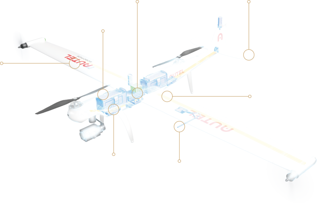
Interchangeable Payload System
*Please refer to the specifications page for specific payloads adaptability.
Tackle any operation with a variety of payload options that can be toolessly swapped to suit mission needs. Dragonfish payloads are designed to be interchangeable between aircraft classes to maximize the value and enhance the mission capability of the system.


| Video Transmission
|
Operating frequency: |
902-928 MHz; 2.4-2.4835 GHz Max Transmitting Distance (unobstructed, free of interference): FCC:10 km CE / MIC:5 km SRRC:5 km |
|
| Data Transmission | Operating frequency: 5.725 - 5.755 GHz |
| Wi-Fi | Protocol: Wi-Fi Direct; Wireless; Display; 802.11a/g/n/ac; Wi-Fi with 2×2 MIMO Operating frequency: 2.400 - 2.4835 GHz 5.150 - 5.250GHz 5.650 - 5.755GHz 5.725 - 5.850 GHz |
| Battery | Type: Li-Po Capacity: 8200mAh Voltage:11.4 V Type:Li-Po Energy:93 Wh Charging time:120 min |
| Run Time | ~3 hrs (Max brightness) ~4.5 hrs (Half brightness) |
| Storage Capacity | ROM 256GB + scalable (TF) |
| Video Output Port | HDMI Port |
| Power Supply Current / Voltage (USB-A port) | 5V / 500mA |
| Operating Temperature Range | -20℃ ~ 40℃ |
| Charging Temperature Range | 0℃ ~ 45℃ |
| Storage Temperature Range | < 1 month: -4° to 140° F (-20° to 60° C) 1-3 months: -4° to 113° F (-20° to 45° C) 3-12 months: -4° to 86° F (-20° to 30° C) |
| GNSS | GPS+GLONASS+Galileo |
| Dimensions | 319×233×74 mm(antennas folded) 319×398×74 mm(antennas unfolded) |
| Weight | 1987g |
| GNSS receiver | Satellite receiving frequency (Simultaneously receive): GPS:L1,L2,L5 BeiDou:B1,B2,B3 GLONASS:F1,F2 Galileo:E1,E5A,E5B Positioning accuracy: Single Point Horizontal: 1.5 m (RMS) Vertical: 3.0 m (RMS) RTK Horizontal: 1 cm+1 ppm (RMS) Vertical: 1.5 cm+ 1 ppm (RMS) 1 ppm: For every 1 km increase in distance, the accuracy will be 1 mm less. For example, the horizontal accuracy is 1.1 cm when the receiving end is 1 km away from the base station. Positioning update rate:1Hz,2 Hz,5 Hz,10 Hz and 20Hz Cold start:< 40s Hot start:< 10s Recapture:< 1s Initialization reliability:> 99.9% Differential data transmission format:RTCM 2.X/3.X |
| Communication | Data link:Image transmission, Wi-Fi |
| Image transmission | Operating frequency:2.4000-2.4835 GHz;902-928 MHz EIRP (Equivalent radiated power): 902-928 MHz FCC:< 30 dBm 2.400-2.4835 GHz FCC:< 30 dBm SRRC/CE/MIC:< 20 dBm |
| Wi-Fi | Operating frequency:5.125-5.25GHz;5.650-5.755GHz;5.725-5.850GHz EIRP (Equivalent radiated power) 5.125-5.25GHz FCC/SRRC:< 26dBm 5.650-5.755GHz MIC:< 20 dBm 5.725-5.850GHz SRRC/FCC:< 26 dBm;CE: < 14 dBm SRRC/CE/MIC:< 20 dBm Communication distance: Mobile station and aircraft: 30 km (FCC) Mobile station and remote control: 200 m (FCC) (Unobstructed and free of interference, when the mobile station is used as a base station and the distance from the mobile station antenna to the bottom of the tripod is 2 m; and when the difference in height between the remote controller and mobile station is less than 10 m, and when the remote controller is 1.2 m from ground level) |
| Electrical characteristics | Power consumption:7.5 W Power supply:5 ~ 20V DC(supports USB PD charging protocol) Battery: Type: lithium ion polymer battery Capacity: 4950 mAh Energy: 57.1 WH |
| Physical properties | Size(Base station body + extension rod):193 mm×177 mm×73 mm Weight:1275g Dustproof and waterproof:IP64 Operating temperature:-20℃ ~ 50℃ |